Hiking the Bald Hills Trail in Jasper National Park: 2026 Guide

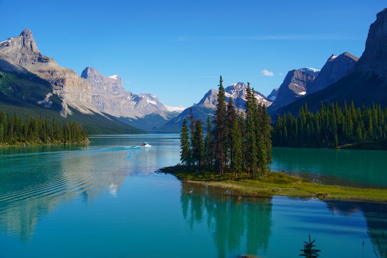
Are you looking for one of the best mountain views in Canada? Look no further than the Bald Hills Trail in Jasper National Park. This summit features the best views of one of Canada’s most beautiful lakes and requires no climbing. Yes, a fairly straightforward trail ends with quite the bang!
In my youth, I dreamed of visiting Canada, but Maligne Lake was never on my radar. In my 20s, I discovered this gem of a lake and knew I had to visit! As I researched the area, I found one hike that provided an aerial view of the lake. I knew I had to see the view for myself!
Unfortunately, on that 2018 trip, I didn’t get a chance to hike Bald Hills. It wasn’t until 2026 that I finally made that dream come true! In this guide, I will show you exactly how we hiked Bald Hills. Let’s dive in!
Bald Hills Trail Jasper: Overview
See my full AllTrails stats to see our exact moving time, total time, and the exact route we took!
Finding the Trailhead
To reach the trailhead, you will drive on the super scenic Maligne Lake Road. Starting from Jasper:
- Drive east and merge onto Highway 16
- After approximately 1 mile (1.6 km), you will turn right onto Maligne Lake Road.
- Shortly after turning, you’ll cross a bridge spanning the beautiful Athabasca River!
- Continue along Maligne Lake Road for 27 miles (44 km), while enjoying the stunning scenery along the way! Wildlife sightings are very common here.
- Follow the road all the way to the end, where you will find a large parking lot. This is not the parking lot for boat tours. Use these exact GPS coordinates to reach the correct trailhead.
- The trailhead features bathrooms and provides access to the Maligne Lake shore, Moose Lake, and Skyline Trails.

Breaking down the trail
As of August 2026, Bald Hills Trail is very well marked, with maps and signage at every junction! Here’s a breakdown of what to expect on the hike:
- 0-1.8 miles (2.9 km): Trailhead to the shortcut junction
- 1.8 – 3.7 miles (5.9 km): The longer route to the first views of Maligne Lake and reconnection point with the shortcut
- Note: The shortcut gains the same elevation (900 feet or 274 m) in roughly half the distance, reconnecting with the main trail at about 2.6 miles (4.2 km).
- 3.7 – 4.9 miles (7.9 km): Stunning meadows and expansive views lead to the junction for the other “Bald Hills summits,” which requires some backtracking. We didn’t have time to visit, but other hikers recommended hitting those summits on the way down.
- 4.9 – 5.5 miles (8.9 km): The final push to the summit!
Note: We didn’t take the shortcut on our descent. However, many hikers suggest taking the standard route to the summit, followed by backtracking to the two additional summits and then descending via the shortcut. We chose not to do this ourselves, but the best route ultimately comes down to personal preference.
Choosing Your Route
When hiking the Bald Hills Trail in Jasper National Park, there’s plenty of debate about the best route to take. Both options ultimately lead to the same destination, but the experience can be different. Here’s a breakdown of the longer route versus the shortcut.
The Long Way
Before taking on the Bald Hills Trail, we researched the two options and decided to take the long way on the ascent. This route follows an old fire road, making the climb more gradual and easier to pace. However, don’t be fooled, though, as there are still several sections that will get your heart pumping.


The Bald Hills Shortcut
The shortcut route is well-marked, with an obvious junction roughly 1.8 miles (2.9 km) from the trailhead. The shortcut then reconnects with the main route at about 2.6 miles (4.2 km). It gains 900 feet (274 m) in 3/4 mile (1.2 km) versus the same elevation gain in about 2 miles (3.2 km) on the longer route.
So what does this mean? Well, the shortcut is much steeper and can be tough on the knees, especially during the descent. Depending on your fitness level and comfort, it may not save as much time as you’d expect.
For experienced hikers with strong fitness levels, the shortcut can be an excellent option, while also providing better views of Maligne Lake throughout the climb. Beginner hikers, however, may find the longer route to be the more enjoyable choice.


The Bald Hills Loop
Many hikers consider the ideal route to be a combination of both trails. We considered this option ourselves. However, since we weren’t familiar with the condition of the shortcut and had a 5:30 PM Maligne Lake Cruise to catch, we decided to stick with the route we knew and return the same way we came up.
Subscribe Here!
If you’re enjoying this content, sign up for My Weekly newsletter!
Step-By-Step Trail Guide
This trail can be confusing, so let’s break it down here so it makes sense. For our hike, we stuck to the standard route the whole way. We didn’t take the shortcut on the ascent or descent, and we didn’t summit any of the subpeaks.
The First Ascent: Forest Section


The first 1.8 miles (2.9 km) follow an old fire road through a fairly dense subalpine forest. At just 1/3 mile (1.2 miles) in, you will see a junction to Moose Lake, which looks phenomenal and could be added onto this hike for an additional 1.5 miles (2.4 km) with 450 feet (137 m) of elevation gain at the beginning or end. I recommend saving it for the end if you have energy to do so!
As the trail continues to climb, it is quite the slog. This section isn’t my favorite because of the bugs! If it weren’t for our bug spray, we’d be eaten alive.
At 1.8 miles (2.9 km), you’ll see a split on your left for the shortcut route. We stuck to the fire road, which begins to steepen here. At about 3.7 miles (5.9 km), the fire road ends, and you will get your first view of beautiful Maligne Lake, shimmering far below.

From here you will take a single-track trail, where you’ll quickly come up on a junction with the end of the shortcut. Both trails lead to the same spot, but the shortcut is notoriously steep.
The Second Ascent: Beautiful Meadow Sections
From here, you will all be on the same trail as you head towards the Bald Hills. Most people basically follow this trail the rest of the way to the main summit, which is the southernmost peak.
Once you break above the tree line, you’re treated to open views of the lush green meadows with views down to Maligne Lake, over to Leah Peak, Samson Peak, and the Queen Elizabeth Range, with distant glaciers clinging to the mountain slopes. This will make the long slog through the mosquito-infested forest very much worthwhile!

You may have noticed some side trails. If you have the energy, take one of these trails up to one of the subpeaks and hike the entire ridge!
The Summit and Lookouts
We followed the lower trail the entire way to the summit, which was a pleasant surprise! The trail wasn’t as steep here, and between the meadows and unexpected views to the West, I can see why so many others were braving this hike!
The true summit is large and rocky, with plenty of places for the 20+ people that day to spread out and enjoy the scenery. Note the chipmunks here are friendly… a little too friendly is you ask me. They will try to steal your food and get in your bags. Make sure everything is sealed and please DO NOT feed them.

The Descent
On the way back, many people opt to summit two of the smaller hills the main trail bypasses. We didn’t have time to do this, so I can’t say if it’s worth the extra effort, but based on photos, if you are really motivated, it may be worth a stop. However, the best views are definitely from the main summit.
As you descend, either retrace your route to the beginning, take the shortcut, or even add in the detour to Moose Lake. We met a solo German man who was heading to Moose Lake on the descent. His reasoning: “Why not?” It doesn’t add much time and looks worthwhile!
Historical Note
The Indigenous peoples (First Nations) who live in the region referred to Maligne Lake as “Chaba Imne,” meaning “Beaver Lake.” The Stoney Nakoda in particular view the lake as a living presence, with the surrounding peaks representing their ancestors and Spirit Island serving as the heart of the lake. This is a very sacred place. Today, the island is one of the most photographed places in the Canadian Rockies!

When To Visit
June to September is generally when the trail is snow-free, making summer easily the best time to visit Maligne Lake and hike the Bald Hills Trail. However, summer can bring its own challenges, such as mosquitoes, gusty winds, and sun exposure above the treeline. Temperatures can also drop in a hurry in the summer, so pack layers.
Make A Day Of It: Nearby Attractions
The Maligne Lake area is home to a whole summer’s worth of adventures! Additionally, the hour-long drive to Maligne Lake contains numerous trailheads. All this said, a full day of adventure is what most people aim for. Here are some suggestions on what to do after your Bald Hills hike!
Maligne Lake & Spirit Island

We couldn’t leave the area without seeing Maligne Lake and Spirit Island! During our July 2026 trip, we debated whether to hike Bald Hills first or cruise the stunning lake. As we were booking our tours well in advance, we noticed that an extra $30 USD per person would give us access to the premium tour, which only sails out at 5:00 PM.
This meant no children on board, plus 30 extra minutes that included more time on Spirit Island and a longer boat ride to the Hall of the Gods. Yes, that’s a real place and also the name of the waffle we enjoyed after the hike.
Speaking of waffles, we gave ourselves extra time between the hike and the boat tour to enjoy the Waffle Hut. I highly recommend it! Parking fills up fast, so we had to park in the overflow lot and walk the steep path down to the boathouse.
In classic Canadian fashion, the north shore of Maligne Lake features a restaurant, gift shop, guest house, the Lake House Cafe, and Waffle Hut. Don’t be discouraged by the bad reviews. Waffle Hut is amazing with great coffee and delicious waffles! If we could have visited a second time, we 100% would!


Pro Tip: If the premium cruise is booked out, I still suggest taking the standard tour. Despite being shorter with less time on Spirit Island, it’s very much worthwhile, offering at least 10 departure times! In 2018, this is the tour we took, and we absolutely loved it!
Other Hikes
There is no shortage of hiking trails in the Maligne Lake area. Between Moose Lake, the Maligne Lake shoreline, Opal Hills to the viewpoint or the full loop, Opal Peak, Mary Schaeffer Loop, and the stunning Skyline Trail with its many variations. Personally, I haven’t had the privilege to complete all these hikes yet, but one day!
FAQ’s
Here are the answers to the questions we are most often asked about hiking the Bald Hills trail!
Is Bald Hills Affected by the 2024 Jasper Fire?
The devastating 2024 Jasper fire left a massive burn scar across the landscape. While I personally find beauty in the renewed landscape, the human and wildlife cost was irreplaceable. That said, the fire did not make it to Maligne Lake, and thus the forest around Bald Hills remains intact.

Do I need bear spray in Jasper?
Yes! I recommend wearing it on your belt throughout the duration of the hike. Do not bury it inside your backpack or even in the side pockets. In the rare chance a bear charges you, every second is precious. Easy access to your bear spray is crucial, and most bear spray comes with a holster.
While many places rent bear spray, such as Jasper Sports for $10 CAD/day, I find it easier to simply purchase it, especially on a longer trip. I usually give mine away on the last day. Also, check your hotel, campground, or Airbnb. Many Airbnb hosts will provide a complimentary Bear Spray, but please return it when you leave.

Will I find parking at Maligne Lake?
There are four parking lots at Maligne Lake, as mentioned at the beginning of this blog. The main parking lot fills up fast, so I highly recommend arriving as early as possible! There’s plenty to explore before your boat tour!
Is my fitness level adequate for the ‘shortcut’
I can’t answer this question for you, but my partner and I discussed the pros and cons and decided the shortcut wouldn’t actually save us time; it would only mess up our knees. After all, we still had several hikes left on our 2-week trip!
Will I encounter a bear?
Like anywhere in the Canadian Rockies, the chance is always there, and the odds are much higher here compared to other places. We hiked Bald Hills on a Wednesday at the end of July; we shared the summit with at least 20 other hikers, so you definitely won’t be alone! We saw no large wildlife on this hike
Is there restroom access at the trailhead?
There are restrooms at all four trailheads, but they can get busy. Once you leave the trailhead, there are no facilities up on the trail. Additionally, for those cruising out to Spirit Island, there are restrooms there.
Is there cell service on the trail?
Don’t rely on it. Service is spotty and unreliable up there, but there is ample trail signage. However, I’d recommend downloading an offline map before you start if possible.
The Wrap-Up: Hiking The Bald Hills Trail in Jasper National Park
I hope by now you can see why the Bald Hills Trail in Jasper National Park is one of the best hikes in the Canadian Rockies! Between views of Maligne Lake and the surrounding Queen Elizabeth Range, this hike is hard to beat! Getting there does require a long slog through the forest, but the views are well worth it!
As you plan your trip, just remember to keep this area as wild as you found it. Follow the Leave No Trace principles, enjoy the views, and above all, be kind and courteous to everyone around you! Happy hiking!